Kent and I sincerely appreciate all the concern for our safety here in Marsh Harbour as the Hurricane Season progresses. We send love to our family and friends, and hugs and prayers to our cruising friends whose boats--their homes--have been lost or damaged as hurricanes passed through.

As of September 24 - Path Summary for the 2017 Atlantic Hurricane Season (Photo courtesy of Wikipedia)
The season officially begins June and ends November 1, when most tropical cyclones are formed in the Atlantic, just west of the African coast. However, Tropical Storm Arlene formed in April and tropical cyclones may form at any time during the year if conditions are right. TS Arlene was the first named storm to develop in the month of April since Ana in 2003. Until Hurricane Franklin, in August, there were no hurricanes and five named Tropical Storms: Arlene (April 19), Bret (June 19), Cindy (June 20), Don (July 17), and Emily (July 31). Tropical Storms have winds of 39 to 73 mph.
Since mid-June, when Bangarang crossed from Florida to Marsh Harbour, Abaco in the Bahamas, there have been eight hurricanes. Bangarang is in a protected marina, "stripped and strapped," and fully insured, as I mentioned in my last post. We are located about 185 miles west of West Palm Beach, Florida, basically at the northern edge of the Bahamas. The fact that eight hurricanes have missed us is something between luck and a miracle.
Hurricane Franklin
Category 1 (74 - 95mph wind)
August 7 - August 10
85mph peak wind speed
Hurricane Franklin was our first hurricane of the 2017 season. Initially making landfall in Mexico as a Tropical Storm, Franklin formed into a hurricane in the Bay of Campeche on August 7 and dissipated quickly. Nowhere near us!

Hurricane Franklin's path; the blue star is Bangarang's location in Marsh Harbor, Abaco (Photo courtesy of AccuWeather)
Hurricane Gert
Category 2 (96 - 110mph)
August 13 - August 17
105 peak wind speed
Just a few days after Hurricane Franklin disappeared, on August 13, Tropical Storm Gert formed northeast of the Bahamas, eventually becoming a hurricane over the western Atlantic. We were ready for Gert just in case the forecasted models were incorrect, but ultimately not in Gert's path.

Hurricane Gert's path; the blue star is Bangarang's location in Marsh Harbor, Abaco (Photo courtesy of AccuWeather)
Hurricane Harvey
Category 4 (130 - 158mph)
August 17 - September 1
130mph peak winds
Hurricane Harvey was one of worst in terms of strength and destruction. Harvey's roots can be traced back to a tropical wave that emerged from the African coast in early August. That disturbance finally formed into Tropical Storm Harvey east of the Lesser Antilles on August 17. Those islands experienced locally heavy rain and gusty winds as Harvey passed through. A few days later, Harvey succumbed to dry air and unfavorable winds in the eastern Caribbean, lessening in strength but pushing northwest for several days and eventually crossing Mexico's Yucatan Peninsula. What remained of Harvey moved back over water in the southwest Gulf of Mexico, then quickly reformed into a tropical depression on August 23. In just 56 hours, Harvey grew from a regenerated tropical depression over the Gulf of Mexico into a Category 4 hurricane as it made landfall with winds at 130 mph near the Texas Gulf Coast late on August 25. Harvey slowly meandered around southern Texas for days as a weakening hurricane and tropical storm. As a tropical storm, Harvey dropped 40-52 inches of rainfall in southeast Texas and southwest Louisiana. All-time continental U.S. tropical cyclone rain records were broken. Harvey triggered flash flooding in parts of Arkansas, Kentucky, and Tennessee at the end of August.
Thankfully for us, Harvey was too far away for us to feel any effects of the hurricane.
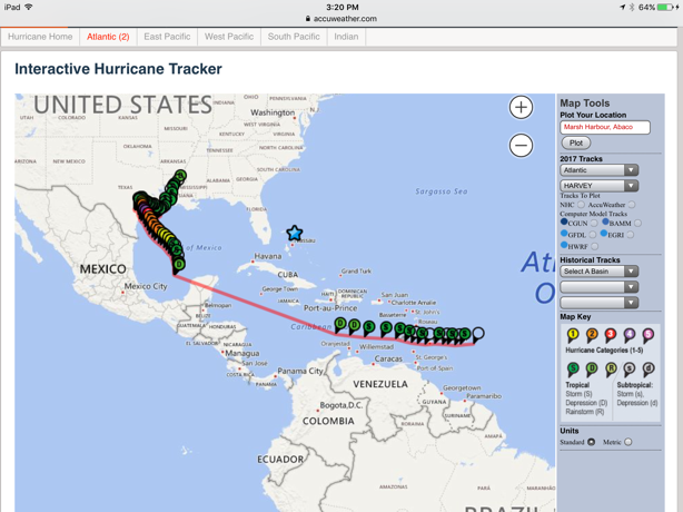
Hurricane Harvey's path; the blue star is Bangarang's location in Marsh Harbor, Abaco (Photo courtesy of AccuWeather)
Hurricane Irma
Category 5 (157mph and above)
August 30 - September 12
185mph wind speed
Next came Hurricane Irma. Irma developed on August 30 near the Cape Verde Islands from a tropical wave that had moved off the west African coast three days prior. Under favorable conditions, Irma rapidly intensified shortly after formation, becoming a Category 2 hurricane within only 24 hours. After fluctuating between Categories 2 and 3, on September 4 and 5, Irma intensified to a Category 5 hurricane and reached its peak intensity with 185 mph winds, making it the second most intense tropical cyclone worldwide so far in 2017, behind only Hurricane Maria, and the strongest worldwide in 2017 in terms of wind speed and low pressure. Irma weakened to a Category 4 hurricane, but the storm attained Category 5 status for a second time while making landfall in Cuba. After dropping to Category 3 intensity after crossing land, the storm re-intensified to Category 4 as it crossed warm waters between Cuba and Florida, before making landfall on Cudjoe Key with maximum sustained winds of 130 mph. Irma dropped back to Category 3 by the time it made a second Florida landfall on Marco Island. Irma weakened to a Category 2 hurricane later that day, the first time it weakened below major hurricane status in over a week, and eventually dissipated off the coast of New England. The storm caused catastrophic damage in Barbuda, Saint Barthélemy, Saint Martin, Anguilla, and the Virgin Islands (many of our favorite islands to visit!) as a Category 5 hurricane. As of September 19, the hurricane had caused at least 102 deaths, including 44 in the Caribbean and 58 in the United States.
We watched Irma very closely because the forecasted models can be incorrect and Irma was relatively close to us. Early on, it appeared we might get a direct hit. Luckily for us, we only experienced high wind with gusts up to 60mph.

Hurricane Irma's path; the blue star is Bangarang's location in Marsh Harbor, Abaco (Photo courtesy of AccuWeather)
Hurricane Jose
Category 4 (130 - 156mph)
September 5 - September 22
155 peak wind speed
Initially projected to impact the Antilles already affected by Hurricane Irma, Jose brought tropical storm force winds to a catastrophically damaged and evacuated Barbuda before changing path. This was the first and so far only time in Atlantic recorded history that two active hurricanes simultaneously had recorded wind speeds of at least 150 miles per hour. On September 14, Jose was downgraded to a tropical storm. A day later, Jose was upgraded to a hurricane. On September 19, the storm was once again downgraded to tropical storm status. Jose is the longest-lived storm of the 2017 Atlantic hurricane season, and the longest-lived Atlantic storm since Nadine in 2012.
Jose is another hurricane we watched closely because of its location and direction, especially with the crazy looping in its path. But we didn't feel any effects from Jose in Marsh Harbour.
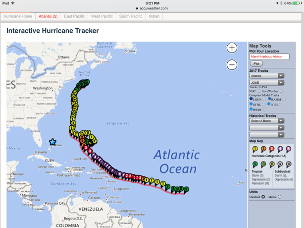
Hurricane Jose's path; the blue star is Bangarang's location in Marsh Harbor, Abaco (Photo courtesy of AccuWeather)
Hurricane Katia
Category 2 (96 - 110mph)
September 5 - September 9
105mph peak wind
Hurricane Katia was a non-issue for us in the Bahamas and the Caribbean because of its location and direction in the Gulf of Mexico.

Hurricane Katia's path; the blue star is Bangarang's location in Marsh Harbor, Abaco (Photo courtesy of AccuWeather)
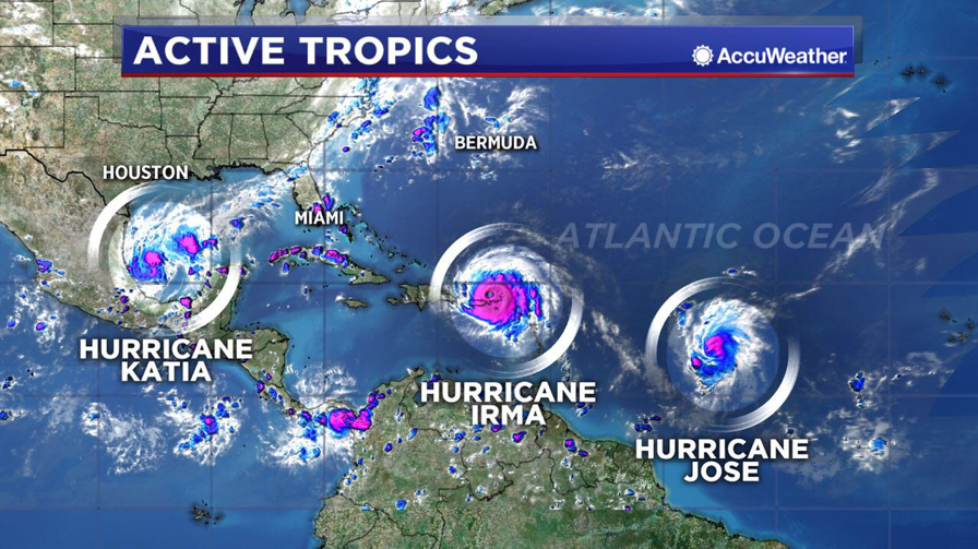
Katia making landfall in Mexico, showing Irma and Jose both still active (left to right) (Photo courtesy of AccuWeather)
Hurricane Lee - Active
Currently Category 3 (111-129mph)
Currently 115mph peak wind speeds
Currently moving at 10mph
Hurricane Lee is still active in the Atlantic and is headed east toward the U.K. Thankfully, Lee has not made landfall, and it looks unlikely it will. We were unaffected by Lee.

Bangarang's location is the blue star; Hurricane Lee's Actual and Forecasted Path (Photo courtesy of the AccuWeather)
Hurricane Maria - Active
Category 5 (157mph and above)
Currently 110-130mph wind speeds
Moving at 9mph
Starting as a tropical wave on September 13, Maria developed into a tropical storm on September 16 east of the Lesser Antilles, building in strength. In remarkably favorable conditions on September 18, Maria intensified, doubling its sustained wind speed from 80 mph to 160 mph and becoming a Category 5 hurricane. Maria made the 2017 season the first since 2007 to feature two Category 5 hurricanes. When Maria made landfall at Dominica the following day, it became the first Category 5 hurricane to strike Dominica, and made 2017 the second season (after 2007) to feature two hurricanes making landfall at Category 5 intensity. After briefly weakening to Category 4 status, Maria reintensified to attain peak winds of 175 mph and a minimum central pressure of 908 mbar, becoming the tenth most intense Atlantic hurricane on record. For 2017, this central pressure is the lowest worldwide thus far. Maria weakened to a high-end Category 4 hurricane with winds of 155 mph before making landfall in Puerto Rico, making Maria the strongest to hit the territory since the 1928 San Felipe hurricane, as well as the most intense hurricane (in terms of central pressure) to hit the territory in recorded history, and the most intense to make landfall anywhere in the United States since Hurricane Camille in 1969. As of September 25, Hurricane Maria has caused at least 59 deaths in Dominica, The Dominican Republic, Guadaloupe, Haiti, Puerto Rico, and the U.S. Virgin Islands, combined. Dominica suffered catastrophic damage and an island-wide communications blackout. The islands of Guadaloupe and Martinique also experienced widespread flooding, damaged roofs, and uprooted trees. Puerto Rico was left without electric power, it's electrical grid effectively destroyed.
We watched Hurricane Maria very closely, as it appeared it might come our way. While we were grateful that we were not in Irma's path, we were dismayed by the additional loss of lives and damage in the Caribbean following the devastation left by Irma.
Today, it was announced that Maria has restrengthened but is moving away from the U.S. east coast.

Bangarang's location is the blue star; Hurricane Maria's Actual and Forecasted Path (Photo courtesy of the National Hurricane Center)
For the remainder of 2017, let's hope we don't have to meet Nate, Ophelia, Philippe, Rita, Sean, Tammy, Vince, or Whitney!
Do You Know Why and How Tropical Cyclones Are Named?
Names have been given to storms (or tropical cyclones) for at least the last 100 years. According to the World Meteorological Organization (WMO), it is easier for people to remember names than numbers and technical terms. When reported by the media, names make it easier to generate interest in major storms and therefore increase how prepared people are for a major storm to hit.
In the beginning, storms were given arbitrary names. An Atlantic storm that ripped the mast off a boat named Antje became known as Antje's hurricane. Then, in the mid-1900s, people started using female names for storms. Then, meteorologists decided to introduce a more organised and efficient system, taking names instead from a list arranged alphabetically. The first storm to occur in a year would be assigned a name beginning with A, and so on. Before the end of the 1900s, forecasters used male names for storms forming in the southern hemisphere.
Since 1953, storms in the Caribbean Sea, Gulf of Mexico and the North Atlantic have been named from lists drawn up by the National Hurricane Center. They are now maintained and updated by the international WMO. The original list featured only women's names and in 1979, men's names were introduced, and now they alternate each year. The naming convention evolved in the 1980's to include French and Spanish names, reflecting the languages of islands affected by Caribbean storms. Twenty-one names are reserved each year. The letters Q, U, X, Y and Z are not used. Names of the most significant storms are retired, determined by the WMO, and replaced. Six lists are used in rotation, so the list for 2017 will be used again in 2023.
If an Atlantic hurricane season has more than twenty-one named storms, the WMO will go to the Greek alphabet, from Alpha to Omega, adding twenty-four more names to use.


